|
last update: Nov-09-2020
Maps of Czech Republic on atlasandmap.com |
| Title/Maker | Year | Measures | Price | |
| ") | Oostenrijk (Westelijk)
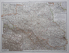
by Kuyper (Kuijper) | 1880 | 20 X 15,5 cm | 19 euro | |  | Böhmen, Mähren und österreichisch-Schlesien
by Richard Andree | 1896 | 49 X 39 cm | 23 euro | |  | Duitschland in ´t jaar 1512; De 10 kreitsen naar de verdeeling van keizer Maximiliaan 1, 1512
by P.W.M. Trap | 1876 | 28 X 22 cm | 32 euro | |  | Germania Antiqua
by F Delamarche | 1830 c | 28 X 24 CM cm | 42 euro | |  | Duitsland en Zwitserland
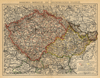
by A. Baedeker | 1844 | 26,5 X 21 cm | 42 euro | | ") | Empire d´Autriche (Empire Austro - Hongrois)
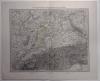
by Migeon, Sengteller, Desbuissons | 1881 | 39 X 31 cm | 52 euro | |  | Kaart Polen, Galizien, Ungern, Kroatien, Siebenbürgen, Moldau och Wallachiet.
by Stieler | 1868 | 22,5 X 21 cm | sold | |  | Duitschland onder de saksiche en frankische Keizers tot 1138
by P.W.M. Trap | 1876 | 28 X 22 cm | sold | |
Plans of cities in Czech Republic on atlasandmap.com |
| Town | Title/Maker | Year | Measures | Price | |
|
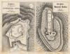 | Grundriss der Burgruine Daubrawska Hora; Grundriss der Burgruine Radina
by C.W. Medau | 1842 | 20 X 15 cm | 21 euro
| |
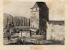
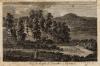
 | Boheems kasteel
by nn | 1825ca | 11 X 8 cm | 21 euro
| | Brno, Brunn:
5 items | Visit our page of the city of Brno, Brunn | Broumov, Braunau
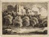
 | Kloster Braunau in Bohmen
by nn | 1850ca | 17 X 14 cm | 21 euro
| | Brunn
 | Brunn
by nn | 1850ca | 15 X 10 cm | 32 euro
| | Dirvic
 | Dirvic
by C. Brantl, J. Richter, C.W. Medou | 1840ca | 19 X 14,5 cm | 26 euro
| | Dresden
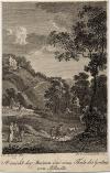 | Ansicht der Ruinen und eines Theils des Gartens von Pillnitz
by A. Zingg, J.A. Darnstedt | 1804 | 6 X 9,5 cm | 21 euro
| | Eger:
4 items | Visit our page of the city of Eger | Hazmburk, Hasenburg
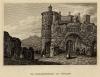
 | Grundriss der Burguine Hasenburg
by F.A. Heber, C.W. Medau | 1845ca | 19,5 X 14,5 cm | 26 euro
| | Hirmkretschen
 | Hirmkretschen an der Elbe
by Chr. Daumerlang | 1850ca | 15 X 10 cm | 21 euro
| | Karlsbad, Karlovy Vary
 | Vue du temple de Dorothee a Carlsbad
by J.A. Darnstedt | 1804 | 12,5 X 8,5 cm | 16 euro
| | Litomysl, Leitomischl
 | Leitomischl
by C.W. Medau, W. Donath | 1845ca | 21 X 17 cm | sold
| | Marienbad, Marianske Lazne:
4 items | Visit our page of the city of Marienbad, Marianske Lazne | Novy Bor, Haida
 | Der Kirchhof zu Haida in Bohmen
by C.W. Medau, W. Donain | 1845 | 21 X 17 cm | sold
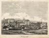
| | Olmutz
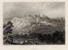
 | Olmutz die Hauptveste Mahrens
by nn | 1850ca | 15 X 10 cm | 21 euro
| | Olmutz, Olomouc
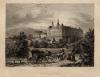
 | Der erzbischofliche Pallast Olmutz
by nn | 1850ca | 17 X 12,5 cm | 26 euro
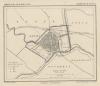
| | Praag, Prague:
4 items | Visit our page of the city of Praag, Prague | Prague, Praha, Prag
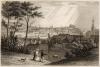
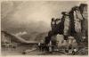
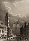 | In Prag der Grosse Ring
by C. Reiss, Poppel | 1850ca | 10 X 15 cm | 52 euro
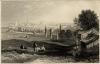
| | Teplice, Teplitz
 | Die Schlackenburg bei Toplitz
by nn | 1850ca | 15 X 10 cm | 32 euro
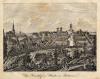
| | Znojmo, Znaim
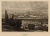
 | Znaim
by nn | 1850ca | 16,5 X 13 cm | 32 euro
| |
| |


 follow us on facebook