
Rediscover your world at Atlas and Map
The place for your antique maps, plans, books and prints
Schoolatlas der Geheele aarde, 29e druk
The place for your antique maps, plans, books and prints
Schoolatlas der Geheele aarde, 29e druk
Only orginal maps an printsOn atlasandmap.com you can find only original items for saleYou will get a certificate of authenticity with each map or print:  |
| HOME - MAPS - PRINTS - BOOKS - INFO | ||||||||||||||||||
Antique map Schoolatlas der Geheele aarde, 29e druk | ||||||||||||||||||
| ||||||||||||||||||
| HOME - MAPS - PRINTS - BOOKS - INFO | ||||||||||||||||||

New:
Maps
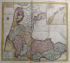
Noordhollands Noordelykste gedeelte
Kuyper maps
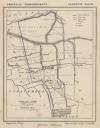
Gemeente Waspik
Prints
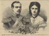
Alexander, Grootvorest, Throonopvolger van Rusland en zijn gemalin Maria Feodorowna
Townplans and views
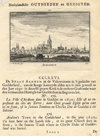
Arnhem: Aernhem
Books and atlasses
FACSIMILE: Gemeente-Atlas van de provincie Friesland 1861

We are on facebook now:
 follow us on facebook
for news, highlighted special items and items on your dutch roots.
Looking for an antique map, historical print or plan? Feel welcome and browse our mapsite atlasandmap.com!
We have maps, made by P.R. Bos, J.F. Niermeyer, B.A. Kwast . Please contact us if you don't find where you are looking for! We ship worldwide.
Maps
Noordhollands Noordelykste gedeelte
Kuyper maps
Gemeente Waspik
Prints
Alexander, Grootvorest, Throonopvolger van Rusland en zijn gemalin Maria Feodorowna
Townplans and views
Arnhem: Aernhem
Books and atlasses
FACSIMILE: Gemeente-Atlas van de provincie Friesland 1861
We are on facebook now:
follow us on facebookfor news, highlighted special items and items on your dutch roots.