Rediscover your world at Atlas and Map
The place for your antique maps, plans, books and prints
Nieuwe Geographische kaart van Europa (Europe)


HOME - MAPS - PRINTS - BOOKS - INFO
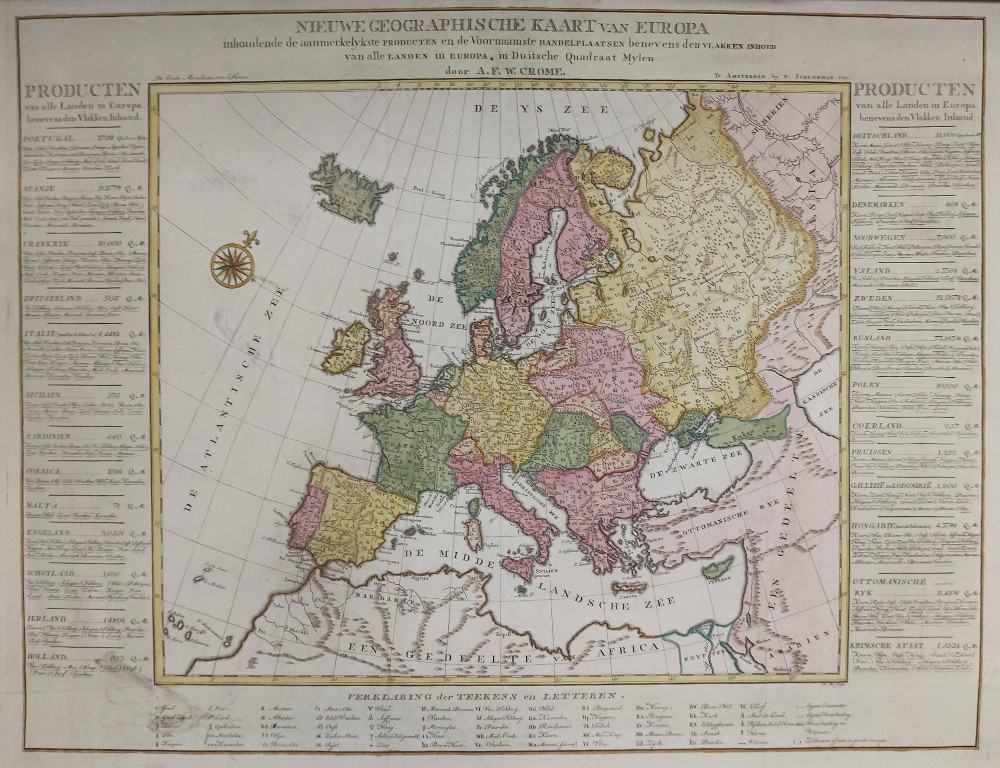
Antique map Nieuwe Geographische kaart van Europa (Europe)
Nieuwe Geographische kaart van Europa by August Friedrich Wilhelm Crome

Details of map Nieuwe Geographische kaart van Europa

TitleNieuwe Geographische kaart van Europa
Typemap
makerAugust Friedrich Wilhelm Crome
Published in1783
Imagesize70 X 53 centimeters
Description

Very special map of Europe: In Dessau Crome developed the work that would make his fame: the first product map of Europe (1782), entitled "Neue Carte Von Europa welche die merkwürdigsten Producte und vornehmsten Handelspläze nebst dem Flächen-Inhalt aller Europäischer Länder in deutschen Quadrat-Meilen enthält.

This version is in Dutch and was published in 1783 by D Schuurman in Amsterdam. The subtitle reads: containing most significant products and the main trading places as well as the flat contents of all European countries in German Quadrate miles.

This Dutch map is very rare. This map shows a record of the main goods and services produced for all parts of Europe.

The map was received very positively, among others by Georg Forster, and turned out to be a financial success for Crome. Today, this map is considered to be the earliest economic thematic map created.

For Holland is indicated: 625 QM, Vee Fockerij, Mee-Krap, Tobacco, East, Iron, Peat, Visschen The paper size is 81 by 63 cm. The card is horizontally reinforced at the back with a band of restoration tape that also repairs a split on the right side in the margin. There are some smudges on the card (see image). Furthermore, a nice clear print on beautiful paper, with very nice coloring.


price
original
map
2277 euros

Payment in all currencies via paypal or banktransfer.
We provide a certificate of authenticity with this map like:
you get a certificata of authenticity with this map

More maps of Europe


All maps on this site are guaranteed original and published in the mentioned period.
HOME - MAPS - PRINTS - BOOKS - INFO
New:
Maps
South America

Kuyper maps
Gemeente Zuilen

Prints
Noord-Hollandsch Meisje

Townplans and views
Delft: La Ville de Delft

Books and atlasses
FACSIMILE: Gemeente-Atlas van de provincie Friesland 1861

We are on facebook now:
follow us on facebook
for news, highlighted special items and items on your dutch roots.


sitemap | recent added | inspired by: kruisbestuiving: benut kennis optimaal - www.kuisbestuiving.nl | contact | RSS | | privacy

Looking for an antique map, historical print or plan? Feel welcome and browse our mapsite atlasandmap.com! We have maps, made by August Friedrich Wilhelm Crome . more maps of Europe like Nieuwe Geographische kaart van EuropaPlease contact us if you don't find where you are looking for! We ship worldwide.