|
last update: Jul-13-2026
Maps of Ireland on atlasandmap.com |
| Title/Maker | Year | Measures | Price | |
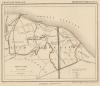
|  | Grootbrittanië en Ierland
by Winkler Prins | 1908 | 21.5 X 28 cm | 21 euro | |  | Ierland
by Kuyper (Kuijper) | 1880 | 10 X 15 cm | 23 euro | |  | übersichtskarte von Grossbritanien und Irland
by Richard Andree | 1896 | 37 X 48 cm | 23 euro | |  | Waterwegen in Grootbrittanië en Ierland
by Winkler Prins | 1908 | 21.5 X 28 cm | 26 euro | |  | Groot-Brittanje en Ierland
by A. Baedeker, Rotterdam | 1844 | 26,5 X 20,5 cm | 32 euro | |  | Groot-Brittanie en Ierland
by P.W.M. Trap | 1872 | 23 X 28,5 cm | 42 euro | |  | Groot Brittanje en Ierland
by F. Bruins | 1884 | 22 X 28 cm | 42 euro | |  | Iles Britanniques
by Félix Delamarche | 1832 | 36 X28 cm cm | 63 euro | |  | REPRODUCTION: Anglia, Scotia et Hibernia
by Gerard Mercator | 1595 | 40 X 32 cm | sold | |  | Irland
by Richard Andree | 1896 | 25 X 38 cm | sold | |  | Iles Britanniques
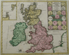
by Migeon, Sengteller, Desbuissons | 1881 | 28.5 X 40 cm | sold | |  | A Map of Great britain and Ireland
by John Blair | 1700 | 56 X 41.5 cm | sold | |  | Insularum Britannicarum
by Abraham Ortelius, J. Jansonius, Petrus Kaerius | 1700 | 51 X 39 cm | sold | |  | Nova Totius Angliae, Scotiae, Et Hiberniae
by Wit, Frederik de | 1670 | 56 X 48 cm | sold | |
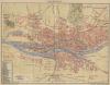
Plans of cities in Ireland on atlasandmap.com |
| Town | Title/Maker | Year | Measures | Price | |
|
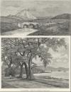
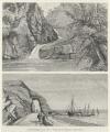
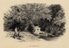 | On the Dargle
by Benjamin Fawcett, naar A.F. Lydon | 1879 | 16 X 11 cm | 21 euro
| |
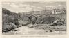
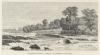
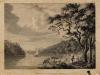 | Dromana, the Seat of Lord Grandison, on the River Blackwater
by W. Walker, naar P. Sandby, R.A. | 1778 | 19 X 14,5 cm | 26 euro
| | 16 plans: Bellfast (Belfast), Dublin, Limerick, Corke, Gallw
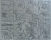 | Drogheda, with the battle at the Boyne and 15 others
by nn | 1750ca | 49 X 39 cm | sold
| | Ballintoy
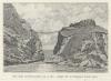
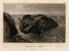 | Carrick-a-Rede
by nn | 1840ca | 16 X 12 cm | 21 euro
| | Carrick-a-Rede
 | Pont volant de Carrick-a-Rede
by O. de Champeaux | 1889 | 12,5 X 8,5 cm | 26 euro
| | Clew Bay
 | Baie de Clew
by O. de Champeaux | 1889 | 16,5 X 8,5 cm | 26 euro
| | Clifden
 | Pont de Clifden
by O. de Champeaux, A. Kohl | 1889 | 16,5 X 9 cm | 16 euro
| | Cork
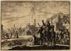 | Plein te Cork waar de bewoners kijken naar de duizenden spreeuwen in de lucht,
by Jan Luyken | 1698 | 15,5 X 11,5 cm | 47 euro
| | County Clare:
2 items | Visit our page of the city of County Clare | Croaghaun
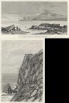 | Le Croghan / Falaises du Croghan
by O. de Champeaux | 1889 | 16,5 X 8,5 cm | 37 euro
| | Doonass
 | Les rapides de Doonass
by Delbosque Brunet, O. de Champeaux | 1889 | 16,5 X 9 cm | 26 euro
| | Dublin:
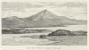
7 items | Visit our page of the city of Dublin | Errigal, Lough Swilly
 | Le mont Errigal / Le Lough Swilly
by O. de Champeaux | 1889 | 16,5 X 8,5 cm | 32 euro
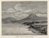
| | Giant´s Causeway
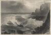 | Der Riesendam von Oberwärts
by A.H. Payne | 1850 | 16,5 X 11,5 cm | 26 euro
| | Giants Causeway:
3 items | Visit our page of the city of Giants Causeway | Glenariff
 | Cascade de Glenariffe / Le Pont Sanglant
by O. de Champeaux | 1889 | 16,5 X 12,5 cm | 32 euro
| | Letterfrack
 | Letterfrack
by F. Meaulle naar O. de Champeuax | 1889 | 17 X 13 cm | 16 euro
| | Lough Beagh, Lough Veagh
 | Le Lough Veagh et le chateau
by O. de Champeaux | 1889 | 16,5 X 9 cm | 26 euro
| | Mulranny
 | Baie de Molhrany
by O. de Champeaux | 1889 | 16,5 X 8,5 cm | 21 euro
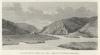
| | Queenstown
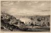 | Queenstown harbour, co. Cork
by W.H. Bartlett, J.P. Heath | 1840ca | 16 X 10,5 cm | 32 euro
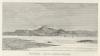
| | Waterford
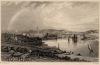 | City of Waterford, from the Dunmore Road
by W.H. Bartlett, W. Taylor | 1840ca | 16 X 10,5 cm | 32 euro
| |
| |


 follow us on facebook