
Rediscover your world at Atlas and Map
The place for your antique maps, plans, books and prints
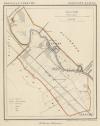
Omstreken van Driebergen (Utrecht)
The place for your antique maps, plans, books and prints
Omstreken van Driebergen (Utrecht)
Only orginal maps an printsOn atlasandmap.com you can find only original items for saleYou will get a certificate of authenticity with each map or print:  |
| HOME - MAPS - PRINTS - BOOKS - INFO | ||||||||||||||||||
Antique map Omstreken van Driebergen (Utrecht) | ||||||||||||||||||
| ||||||||||||||||||
| HOME - MAPS - PRINTS - BOOKS - INFO | ||||||||||||||||||

New:
Maps
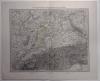
Sud-Westliches Deutschland und die Schweiz
Kuyper maps
Gemeente Zuilen
Prints
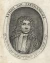
Antoni van Leeuwenhoek, Lid van de Koninglyke societeyt in London, geboren tot Delft Anno 1632
Townplans and views
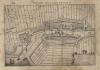
Muiden: Muyden
Books and atlasses
FACSIMILE: Gemeente-Atlas van de provincie Friesland 1861

We are on facebook now:
 follow us on facebook
for news, highlighted special items and items on your dutch roots.
Looking for an antique map, historical print or plan? Feel welcome and browse our mapsite atlasandmap.com!
We have maps, made by Craandijk . more map of Utrecht like Omstreken van DriebergenPlease contact us if you don't find where you are looking for! We ship worldwide.
Maps
Sud-Westliches Deutschland und die Schweiz
Kuyper maps
Gemeente Zuilen
Prints
Antoni van Leeuwenhoek, Lid van de Koninglyke societeyt in London, geboren tot Delft Anno 1632
Townplans and views
Muiden: Muyden
Books and atlasses
FACSIMILE: Gemeente-Atlas van de provincie Friesland 1861
We are on facebook now:
follow us on facebookfor news, highlighted special items and items on your dutch roots.